To receive our daily post and the occasional announcement:

Washington, D.C,
Washington, D.C.'s L'Enfant Plan was developed in 1791 by Major Pierre Charles L'Enfant for George Washington, the first President of the United States. L’Enfant designed a compass-aligned grid for the city’s streets, with intersecting diagonal avenues that were later named after the states of the union. The diagonal avenues also intersect with the north-south and east-west streets at circles and rectangular plazas in order to create more open, green spaces. Lastly, L'Enfant laid out a 400 foot-wide (122 meter) garden-lined “grand avenue” - what is now know as the National Mall – that connects the US Capitol Building, the Washington Monument, and the Lincoln Memorial (the latter two are visible at right in this Overview).
38.890556°,-77.020278°
Maxar Technologies
Venice
Venice, Italy, is situated upon 118 small islands that are separated by canals and linked by bridges. After a series of heavy storms, much of the city has been flooded this week as high tide rose to more than 61 inches (156 cm) above average sea level. At least 11 people have been killed due to storms across the country, and flood waters in many of Venice's streets reached knee height at the beginning of the week. With tide waters expected to rise to perilous levels in the coming decades, the city has constructed 78 giant steel gates across the three inlets through which water from the Adriatic could surge into Venice’s lagoon.
45.437500°,12.335833°
Maxar Technologies

Jacksonville Turbine Interchange
A turbine interchange connects the SR 9A and SR 202 in Jacksonville, Florida, USA. Also known as a whirlpool interchange, this structure consists of left-turning ramps sweeping around a center interchange, thereby creating a spiral pattern of right-hand traffic. This type of junction is rarely built, due to the vast amount land that is required to construct the sweeping roads.
30.253056°,-81.516194°
Maxar Technologies

Tel Aviv
Located on the coast of the Mediterranean Sea, Tel Aviv is the second most populous city in Israel and is recognized as the country's financial center and a major technology hub. With a city plan dating back to the 1920’s, Tel Aviv was constructed with a hierarchical system of streets laid out in a grid and large blocks consisting of small-scale dwellings that surround central, open spaces.
32.078333°,34.769000°
Maxar Technologies
Sydney Opera House
The Sydney Opera House hosts more than 1,500 shows each year in its various performance halls, drawing a total attendance of approximately 1.2 million people. While the building’s famous “shell” design appears uniformly white from a distance, it actually features a subtle chevron pattern composed of tiles in two colors: glossy white and matte cream.
-33.858667°,151.214028°
Nearmap

Sydney
Check out this stunning view of Sydney, Australia. The city is the most populous on the continent with more than five million residents. The geography of the city - located on the Tasman Sea and built around numerous harbors and inlets - is captured in this Overview.
-33.867906°,151.201237°
Maxar Technologies

Sunset District, San Francisco
This Overview captures the Sunset District — the largest and most populous neighborhood in San Francisco, California. Bordered by Golden Gate Park on its northern side, the district is home to more than 85,000 people. Sunset is often referred to as “The Avenues” because it is spanned by numbered north-south thoroughfares.
37.750034°,-122.519085°
Maxar Technologies

Stelvio Pass
The Stelvio Pass in northern Italy is the highest paved roadway in the Eastern Alps, with an elevation of 2,757 meters (9,045 feet) above sea level. Only accessible in the summer months, the road and its 75 hairpin turns are sometimes scaled during the famous Giro d’Italia cycling race.
46.528611°,10.452777°
Maxar Technologies

Spiral Jetty
This Overview captures Spiral Jetty, an earthwork sculpture by Robert Smithson, consisting of a 1,500-foot-long (460 m), 15-foot-wide (4.6 m) counterclockwise coil jutting from the northeastern shore of the Great Salt Lake in Utah, USA. Smithson reportedly chose this site because of the vibrant colors of the water (salt-tolerant bacteria and algae thrive here in 27% salinity) and its connection with the primordial sea.
41.437611°,-112.669556°
Maxar Technologies

Spain Greenhouses
Greenhouses in Almeria, Spain, cover approximately 20,000 hectares of land (more than 75 square miles). The use of plastic covering (known as "plasticulture") is designed to increase produce yield, increase produce size, and shorten growth time. For a sense of scale, this Overview shows roughly six square miles. This image is on display right now at our exhibition at theprintspace in Shoreditch, London. We're also selling prints of it, and – thanks to theprintspace – we are able to offer FREE shipping throughout Europe during the exhibition, which ends November 26th! Visit to take advantage of this exclusive offer.
36.868331°,-2.368688°
Maxar Technologies

Singapore Tankers
Check out this Overview, which captures cargo ships and tankers — some weighing up to 300,000 tons — outside of the entry to the Port of Singapore. The facility is the world's second-busiest port in terms of total tonnage, shipping a fifth of the world's cargo containers and half of the world's annual supply of crude oil.
1.255944°,103.781000°
Maxar Technologies
Shadegan Lagoon
Dendritic drainage systems are seen around the Shadegan Lagoon by Musa Bay in Iran. The word ‘dendritic’ refers to the pools’ resemblance to the branches of a tree, and this pattern develops when streams move across relatively flat and uniform rocks, or over a surface that resists erosion.
30.456750°,48.929444°
Maxar Technologies
Seoul
Seoul is the capital and largest metropolis of South Korea, with more than 25 million residents in its metropolitan area. Strategically situated on the Han River, Seoul’s history can be traced back more than 2,000 years to 18 BC, when it was founded by members of the Baekje Kingdom. In recent years, the city has experienced massive economic growth and is one of the top 10 wealthiest cities in the world with a GDP of more than $700 billion (USD).
37.566667°,126.966667°
Maxar Technologies

San Francisco Bay Salt Ponds
Salt ponds are seen on San Francisco Bay in northern California, USA. Here water is channelled into large ponds and exits through natural evaporation. The salt that remains can then be collected. The massive ponds get their vibrant reddish colors from the algae that thrive in the extremely salty water. Approximately 80% of this wetlands area – approximately 16,500 acres – has been developed for salt mining.
37.504215°,-122.036887°
Maxar Technologies

New Bullards Bar Reservoir Houseboats
This Overview captures houseboats floating peacefully on the New Bullards Bar Reservoir in Yuba County, California. The exposed shoreline across the bottom of the image appears when the reservoir water level is low. Want to display this image in your home? Head over to our to find it and other Overviews for sale!
39.429030°,-121.130100°
Maxar Technologies

Port of Rotterdam
Shipping containers are seen at the Port of Rotterdam in the Netherlands. From 1962 until 2002, the facility was the world’s busiest port, but was overtaken first Singapore and later Shanghai. In 2015, Rotterdam ranked as the world’s sixth-largest port in terms of annual cargo tonnage.
51.952790°,4.053669°
Maxar Technologies

Port of Rotterdam
Two container ships are docked at the Port of Rotterdam in the Netherlands. From 1962 until 2002 it was the world’s busiest port, but was overtaken first by the the port in Singapore and later by the facility in Shanghai, China. Container ships such as these can weigh up to 300,000 tons and extend up to 1,200 feet (366 meters).
51.950990°,4.065449°
Maxar Technologies

Port Newark
Shipping containers are stacked at the Port Newark Container Terminal in Newark, New Jersey, USA. The massive facility handles over 600,000 shipping containers every year and has begun expansion projects that will increase annual capacity to 1.1 million containers by 2030.
40.681667°,-74.150556°
Nearmap
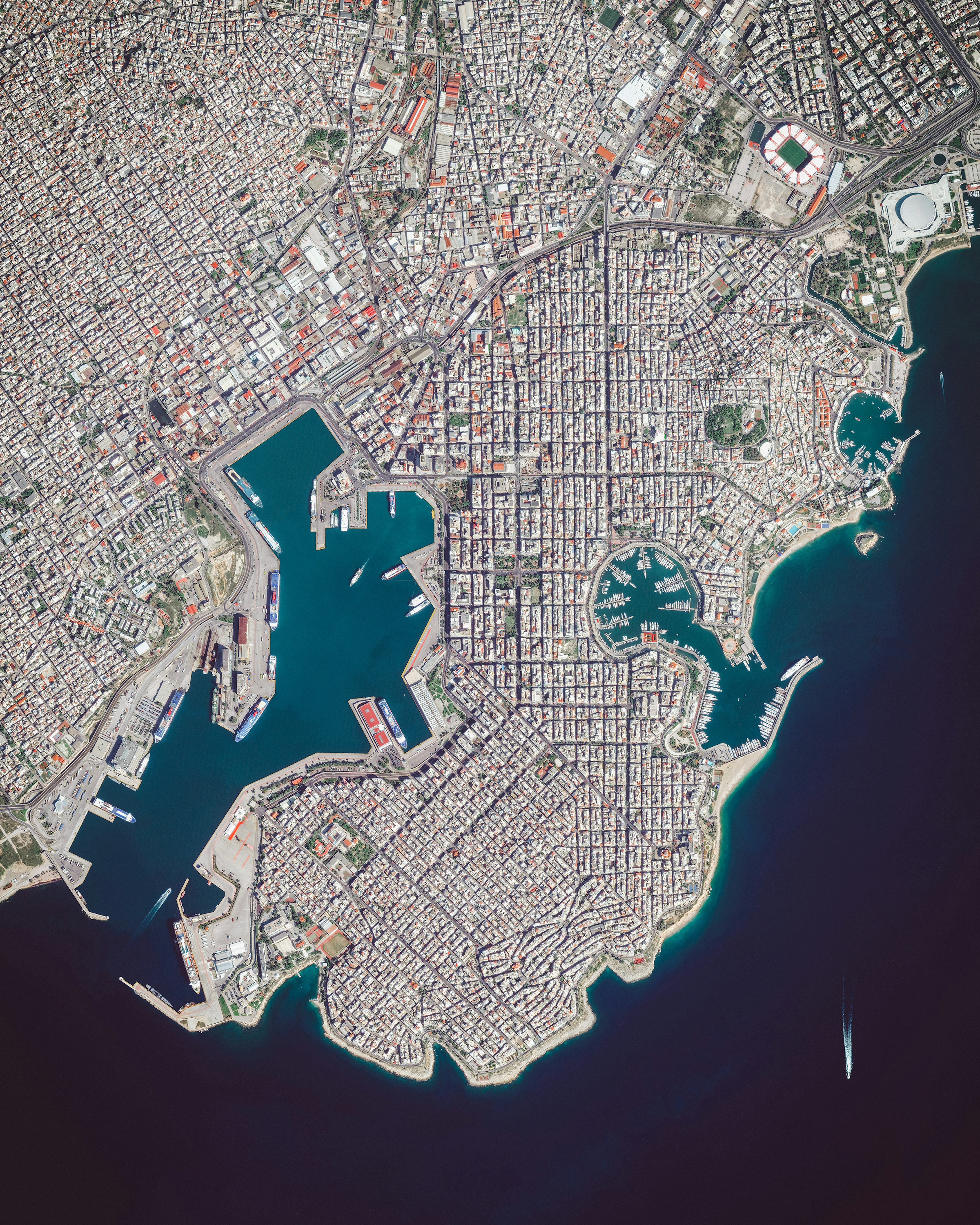
Piraeus
Piraeus is a port city in Greece, roughly 7 miles (12 km) outside Athens. Since ancient times, it has served as a vital trade and transportation hub, and its port is currently the busiest passenger port in the country. In fact, the Port of Piraeus was the busiest in all of Europe in 2014, when it handled 18.6 million passengers.
37.936194°,23.642250°
Maxar Technologies

Perito Moreno Glacier
The Perito Moreno Glacier is located in Santa Cruz Province, Argentina. The 250 square kilometer (97 square mile) ice formation stretches for 30 kilometres (19 miles) and represents the world’s third largest reserve of fresh water.
-50.536843°,-73.195237°
Maxar Technologies
