To receive our daily post and the occasional announcement:

Coal Trains in Alliance, Nebraska
Coal trains — some full, others empty — idle in a railyard next to a pivot irrigation circle in Alliance, Nebraska, USA. The city is located in the Powder River Basin — one of the world’s largest coal-mining areas — and serves as a stopping point for trains en route to power plants in the Midwest and Southern parts of the country.
42.082523°,-102.890045°
Maxar Technologies

Luoyuan Bay Aquaculture
Seafood farms cover the surface of Luoyuan Bay in the Fujian province of China. Underneath the water is a vast network of lines, cages, and nets for the growth of various seafood species including crabs, lobsters, scallops, and carp. For a sense of scale, approximately 2.3 square miles (6 square km) of the bay is seen here.
26.408924°,119.741132°
Maxar Technologies

Port of Savannah
The Port of Savannah is a major U.S. seaport located in the city of Savannah, Georgia. Its facilities for oceangoing vessels line both sides of the Savannah River, approximately 18 miles (29 km) from the Atlantic Ocean. Between July 2018 and 2019, a record 4.5 million twenty-foot equivalent container units were moved at the Port of Savannah.
32.128705°,-81.151907°
Nearmap

Raung Volcano
Lava and ash billow out of Raung, one of the most active volcanoes on the island of Java in Indonesia. Raung towers more than 10,000 feet above sea level and was captured here during a powerful eruption in 2015 with a short-wave infrared satellite camera. The ash produced during this activity forced the closure of numerous airports on the island.
-8.125000°,114.041667°
Maxar Technologies

La Plata
The planned city of La Plata — the capital city of the Province of Buenos Aires, Argentina — is characterized by its strict, square grid pattern. At the 1889 World’s Fair in Paris, the new city was awarded two gold medals in the categories “City of the Future” and “Better Performance Built.” La Plata has a population of around 765,000 people.
-34.921111°,-57.954444°
Maxar Technologies

Boeing 737 Max Parking Lot
Dozens of 737 MAX jetliners cover a parking lot at Boeing's factory in Seattle, Washington. This model has been grounded since March following two fatal crashes in less than six months. July was Boeing's fifth consecutive month without a new order for the 737 MAX and its least productive month for plane deliveries since November 2008.
47.529245°,-122.309162°
Nearmap

Moscow, Russia
Moscow is the capital and most populous city in Russia with 13.2 million residents within the city limits and approximately 20 million in its metropolitan area. The city is organized into five concentric transportation rings that surround the Kremlin. The two innermost rings are seen here.
55.750000°,37.616667°
Maxar Technologies

Canyon Lake
Canyon Lake is a city and gated community in southern California, with a population of slightly more than 11,000 people. Constructed as a master-planned community in 1968, it is one of just five gated cities in the state. In 2006, it was featured in “United Gates of America,” a BBC documentary that explored why people live in gated communities and what effects it has on them.
33.681444°,-117.250389°
Nearmap

Mesa Mobile Homes
Mobile home and RV parks cover a considerable portion of eastern Mesa, Arizona. Pictured on the right side of this Overview is one such park — the Venture Out RV Resort, a master-planned retirement community with more than 1,740 homes. Located about 20 miles (32 km) outside of Phoenix, Mesa is the largest suburban city by population in the United States, with upwards of 500,000 residents.
33.410401°,-111.724340°
Nearmap

Saskatoon Airplanes
Several jets are parked outside a hangar at the John G. Diefenbaker International Airport in Saskatoon, Saskatchewan, Canada. With two runways, nine passenger bridges and three ground-loading positions, the airport handles just under 1.5 million passengers per year. By contrast, the busiest airport in Canada (Toronto Pearson International) handles nearly 50 million passengers annually.
52.169389°,-106.681472°
Nearmap
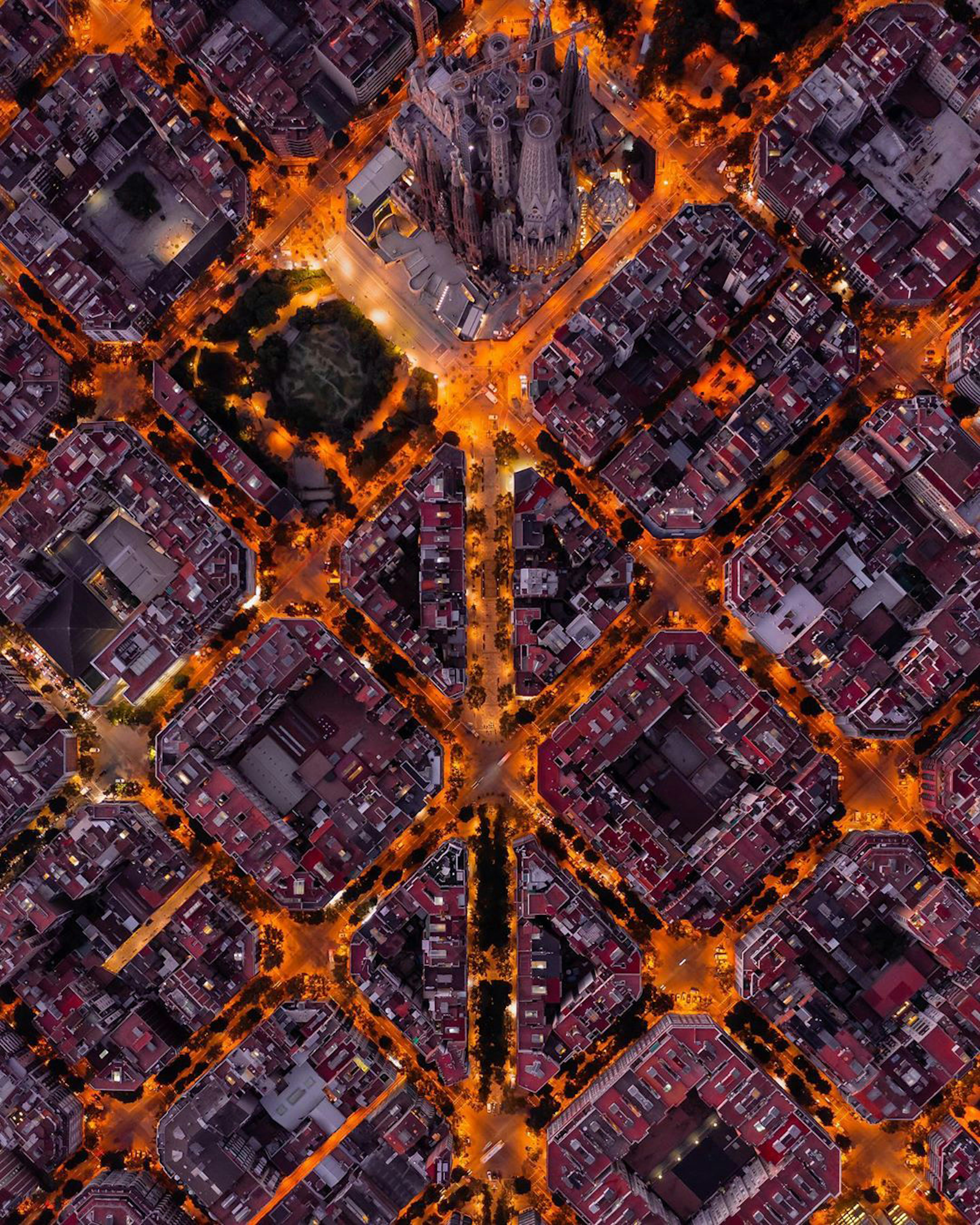
Sagrada Familia at Dusk
This drone shot captures the Sagrada Família neighborhood of Barcelona, Spain, at dusk. Pictured at the top of the frame is the neighborhood’s namesake, the Basílica de la Sagrada Família, a large unfinished Roman Catholic basilica designed by famed architect Antoni Gaudí. The structure is the most-visited tourist attraction in the city, bringing in more than 3 million visitors per year.
41.403561°,2.174347°
The Drone Lad

The Islands, Gilbert, Arizona
The Islands is a master-planned community within the town of Gilbert, Arizona. Located approximately 16 miles (25.7 km) southeast of Phoenix, the community contains 2,633 residential homes, 272 apartments and 26 commercial properties. In recent decades, Gilbert has made a rapid transformation from a small, agriculture-based community to a suburban center, seeing its population grow from 5,717 in 1980 to upwards of 208,000 in 2010.
33.343010°,-111.815760°
Nearmap

Third Avenue Bridge, Minneapolis, Minnesota
Cars make their way across the Third Avenue Bridge in Minneapolis, Minnesota. Originally known as the St. Anthony Falls Bridge, the multi-arched bridge carries road traffic across the Mississippi River and crosses right above the upper fringes of Saint Anthony Falls. It is 2,223 feet (667 m) long, 54 feet (16.4 m) wide, and has a clearance of 42 feet (12.8 m).
44.982972°,-93.259417°
Nearmap

Fall Foliage in Nashua, New Hampshire
Colorful fall foliage blankets the landscape around Nashua, New Hampshire. With the arrival of autumn and colder temperatures in the northeastern United States, leaves begin to change colors and create vibrant views like this one. Thousands of tourists flock to New Hampshire (and the rest of New England) during this season to take advantage of scenic drives and “leaf-peeping” tours.
42.760321°,-71.484009°
Nearmap
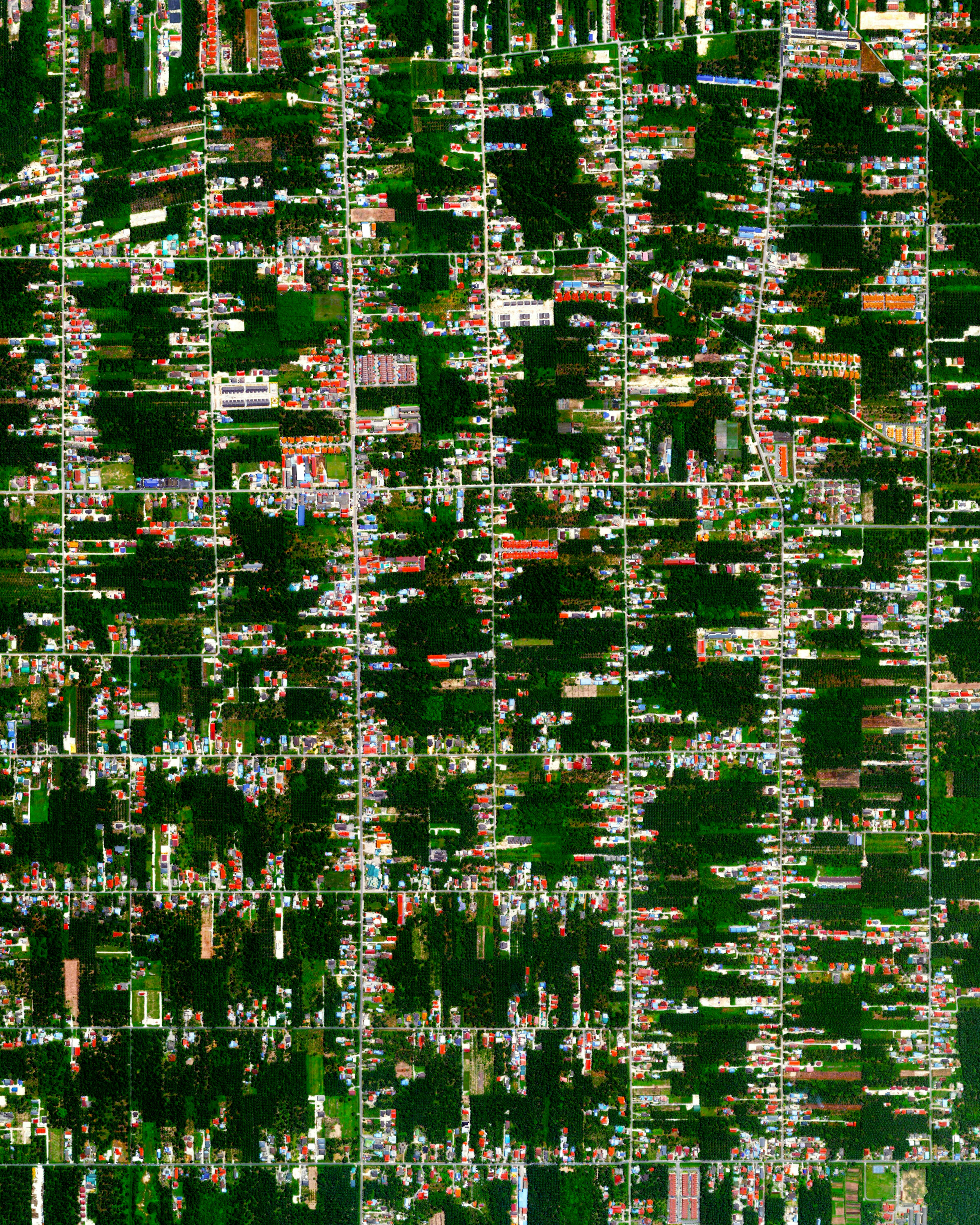
Teluk Panglima Garang, Malaysia
Residential development is seen among tracts of palm trees and other vegetation in the town of Teluk Panglima Garang, Malaysia. In the early 20th century, this area was mostly made up of small agricultural villages, but has since grown due to industrial activity and palm oil production. With relatively new road networks and infrastructure, many manufacturers here transport their goods to the city of Kuala Lumpur and its international airport.
2.936996°,101.452317°
Maxar Technologies

Seaweed Farms off South Korea's southern coast
Seaweed farms surround Sisan Island, off the south coast of South Korea. In “fields” like these, seaweed is often grown on ropes attached to buoys, which hold the crop near the water’s surface. The southern waters of South Korea are ripe with aquaculture operations like these; in fact, this region produces 90% of the nation’s seaweed crop.
34.396552°,127.261377°
Maxar Technologies

Hurricane Dorian
This image, captured by the European Space Agency's Copernicus Sentinel-3 satellite, shows Hurricane Dorian pummeling the Bahamas on Monday, September 2. Having reached Category 5 intensity with sustained winds of 185 mph (295 km/h), the storm is reported to be one of the most powerful Atlantic hurricanes on record. It is currently a Category 2 hurricane and is expected to continue up the southeastern coast of the United States. Several fatalities have been recorded and numerous homes and infrastructure have been destroyed.
24.250000°,-76.000000°
ESA - European Space Agency
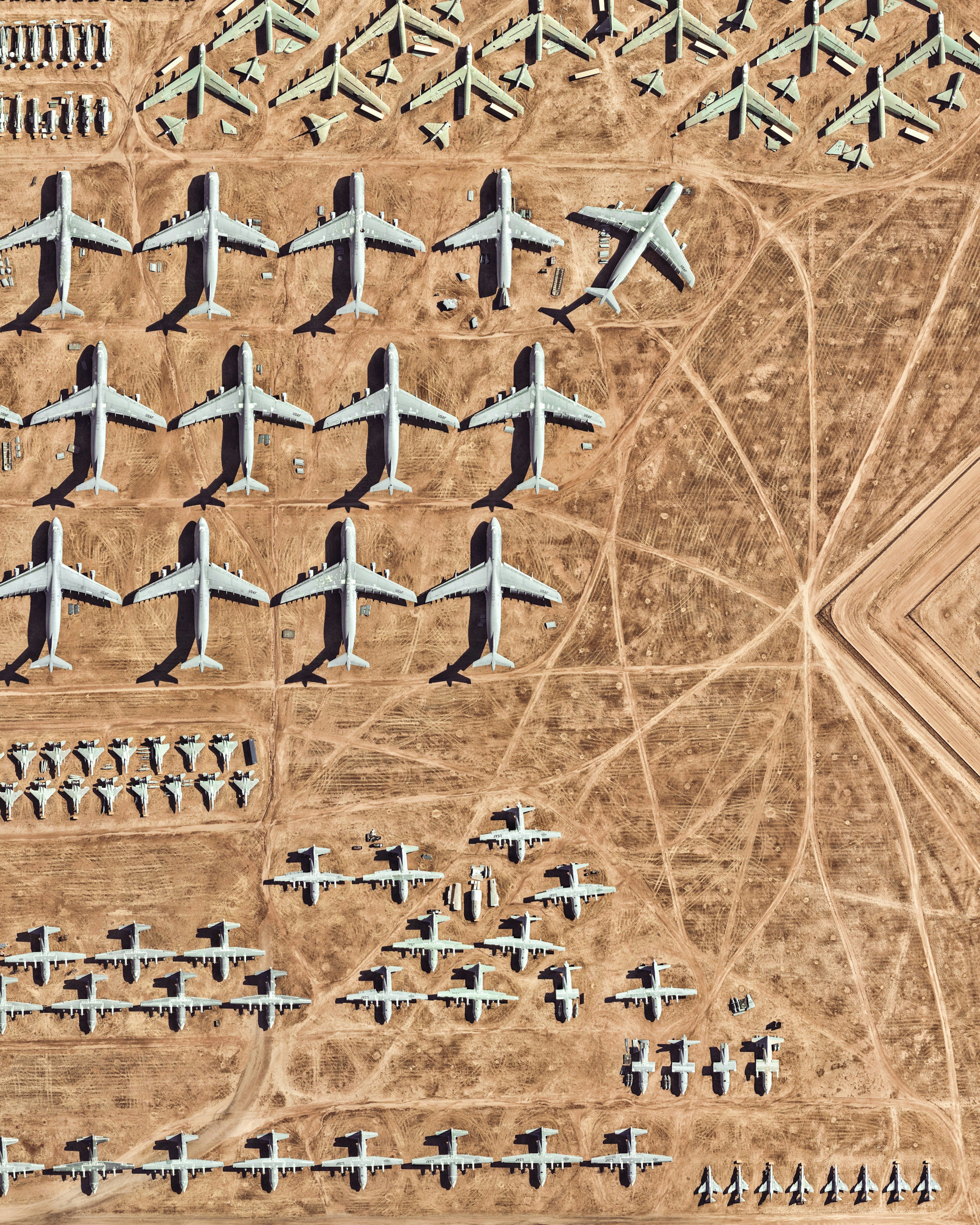
Davis–Monthan AFB
The largest aircraft storage and preservation facility in the world is located at Davis–Monthan Air Force Base in Tucson, Arizona. The facility - run by the 309th Aerospace Maintenance and Regeneration Group - contains more than 4,400 retired American military and government aircraft.
32.150574°,-110.827969°
Nearmap

Wadi Rum
Wadi Rum is a village that has been populated by humans since prehistoric times (8th century BC). Early inhabitants left their mark in the form of rock paintings, which have been thoroughly analyzed by historians. The area has also served as a film set for movies such as The Martian and Star Wars Rogue One.
29.574298°,35.412261°
Maxar Technologies

Whakaari / White Island
Whakaari, also known as White Island, is an active stratovolcano, situated 48 km (30 mi) from the North Island of New Zealand in the Bay of Plenty. Whakaari is New Zealand’s most active volcano, and has been built up by continuous eruptions over the past 150,000 years. The island is approximately 2 km (1.2 mi) in diameter and rises to a height of 321 m (1,053 ft) above sea level.
-37.516667°,177.183333°
Maxar Technologies
