To receive our daily post and the occasional announcement:
Chicago
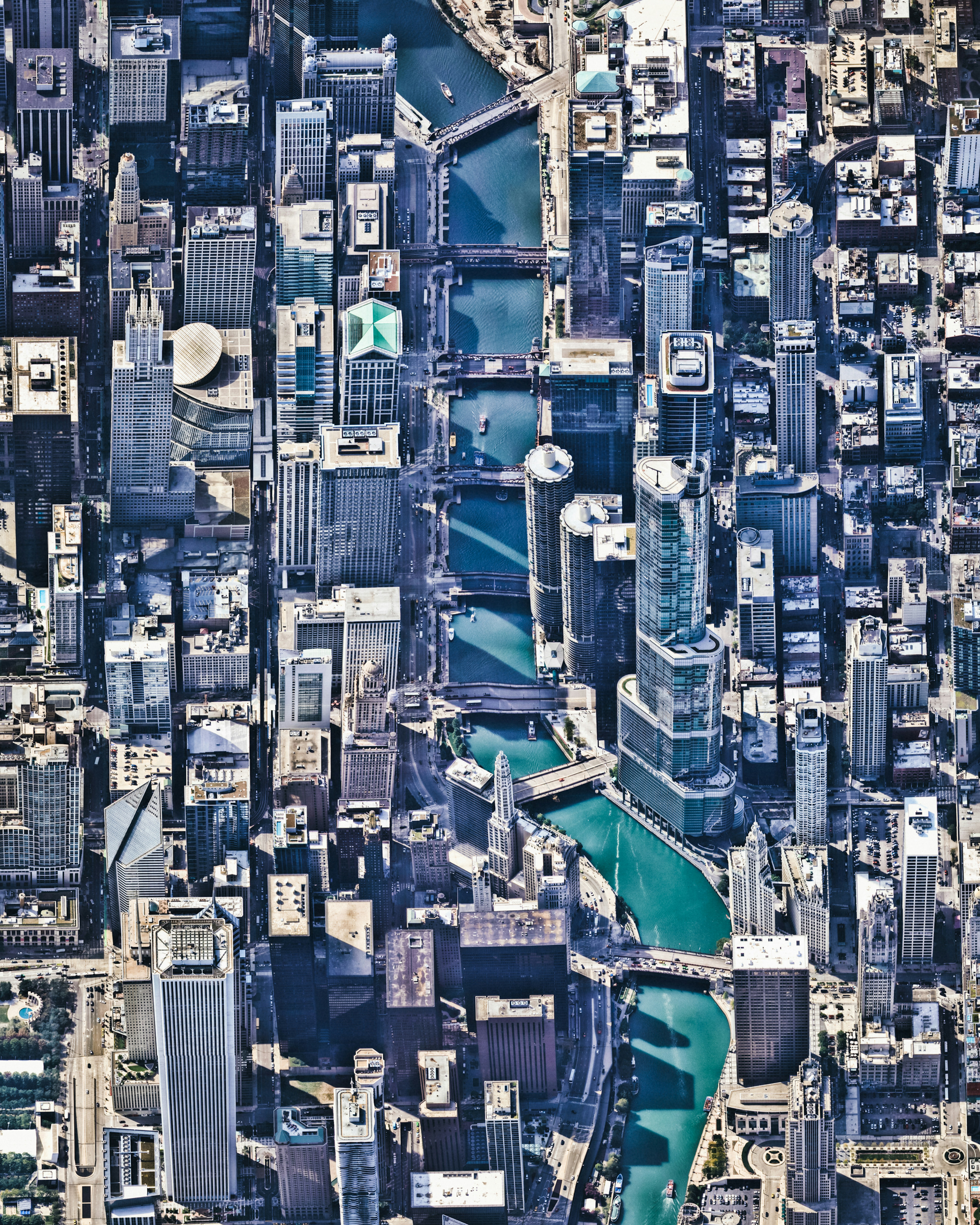
Chicago, Illinois, is the third most populous city in the United States, with more than 2.7 million residents. This Overview shows the Chicago River flowing through the city center, dividing The Loop (left) and Near North Side (right) communities. Many of the city’s prominent skyscrapers can be seen from this perspective, including the Trump International Hotel and Tower, the Aon Center, and Grant Thornton Tower.
41.888889°,-87.626667°
Nearmap

McMurdo Station
McMurdo Station is a United States research center on the southern tip of Ross Island in Antarctica. It is one of three U.S. Antarctic science facilities and the largest community on the continent, capable of supporting 1,258 residents. It boasts a harbor, three airfields, a heliport, more than 100 buildings, and Antarctica’s only two ATMs.
-77.840119°,166.644358°
Maxar Technologies

Pierce County Container Terminal
The Pierce County Container Terminal is part of the Port of Tacoma, located in Washington State. The 140-acre (56.7 hectare) facility has two berths totaling 2,087 feet (636 m) in length and seven cranes. Every year, the Port of Tacoma handles between 9 and 13 million tons of cargo and more than $25 billion of commerce.
47.253944°,-122.369778°
Nearmap

Roebuck Bay
Roebuck Bay is a 210-square-mile (550 sq. km) tropical marine embayment in the Kimberley Region of Western Australia. Much of the Bay’s eastern edge contains tidal creeks, which create vein-like patterns on its red sandy beaches. Mangrove swamps connected to these tidal creeks serve as important nursery areas for marine fish and crustaceans.
-18.085832°,122.265540°
Maxar Technologies

Mount Calvary Cemetery
Mount Calvary Cemetery is a cemetery in Linden, New Jersey, belonging to the St. Adalbert Roman Catholic Church. Saint Adalbert (Wojciech) is the patron saint of Poland and thus an important figure for many living in the city of Linden. More than 13% of residents there are of Polish origin and 15.6% of residents primarily speak Polish at home.
40.633694°,-74.235028°
Nearmap
Kensico Reservoir Bridge
A bridge crosses the Kensico Reservoir in the town of Valhalla, New York. Located about 15 miles (24 km) north of New York City, the reservoir stores waters received from the Catskill Mountains and provides a site for fishing and boating recreation. With an average depth of nearly 44 feet (13.5 m) and a maximum depth of 120 feet (37 m), it can hold 30 billion gallons (113 billion liters) of water.
41.098889°,-73.745194°
Nearmap

London At Night
Check out this amazing Overview of London at night. As the capital and most populous city in Great Britain, London is also one of the leading tourist destinations in the world. In 2015, it was ranked as the most visited city in the world, with more than 65 million visits. We’re excited to announce that one week from Thursday, on November 15th, we’ll be hosting the opening for our first ever exhibition in London at theprintspace in Shoreditch. The event is open to the public and the exhibition will continue through November 26th, so just click here for more info: . Hope to see some of you there!
51.507222°,-0.127500°
NASA

Chongqing
Chongqing is a major city in southwest China with an urban population of nearly 8.2 million. Located along the Jialing (left) and Yangtze (right) Rivers, it serves as one of the most important inland ports in China. Numerous luxury cruise ships terminate at Chongqing, and coal, raw materials and containerized goods also pass through the city aboard cargo ships.
29.558333°,106.566667°
Maxar Technologies

Mill Creek Wastewater Treatment Plant
The Mill Creek Wastewater Treatment Plant is the largest plant in the Metropolitan Sewer District of Greater Cincinnati, Ohio, treating roughly 100 million gallons (378 million liters) of wastewater a day. The sewer district’s service area encompasses more than 290 square miles (751 sq. km) and serves a population of more than 850,000.
39.111111°,-84.546778°
Nearmap

Camp Wildfire
The Camp Fire, which is currently burning in Northern California, has become the deadliest wildfire in state history with a death toll of 42 as of this morning. The blaze has scorched more than 117,000 acres (47,000 hectares), destroyed more than 7,000 structures and forced 52,000 people to evacuate their homes. The fire is roughly 30 percent contained at the moment.
39.759259°,-121.597808°
NASA

Mossel Bay
Mossel Bay is located on the Cape St. Blaize Peninsula, jutting off of South Africa into the Indian Ocean. The harbor town is home to roughly 130,000 people and is recognized as a center for both tourism and agriculture.
-34.185460°,22.146049°
Maxar Technologies

Chausey
Chausey is a group of small islands, islets and rocks in the English Channel, off the coast of Normandy, France. The archipelago comprises 365 islands at low tide, but only 52 island at high tide. Grande-Île, the main island, is 0.93 miles (1.5 km) long and 0.3 miles (0.5 km) wide at its widest. It is the only inhabited island in the Chausey group, with roughly 30 residents.
48.870278°,-1.822500°
Maxar Technologies
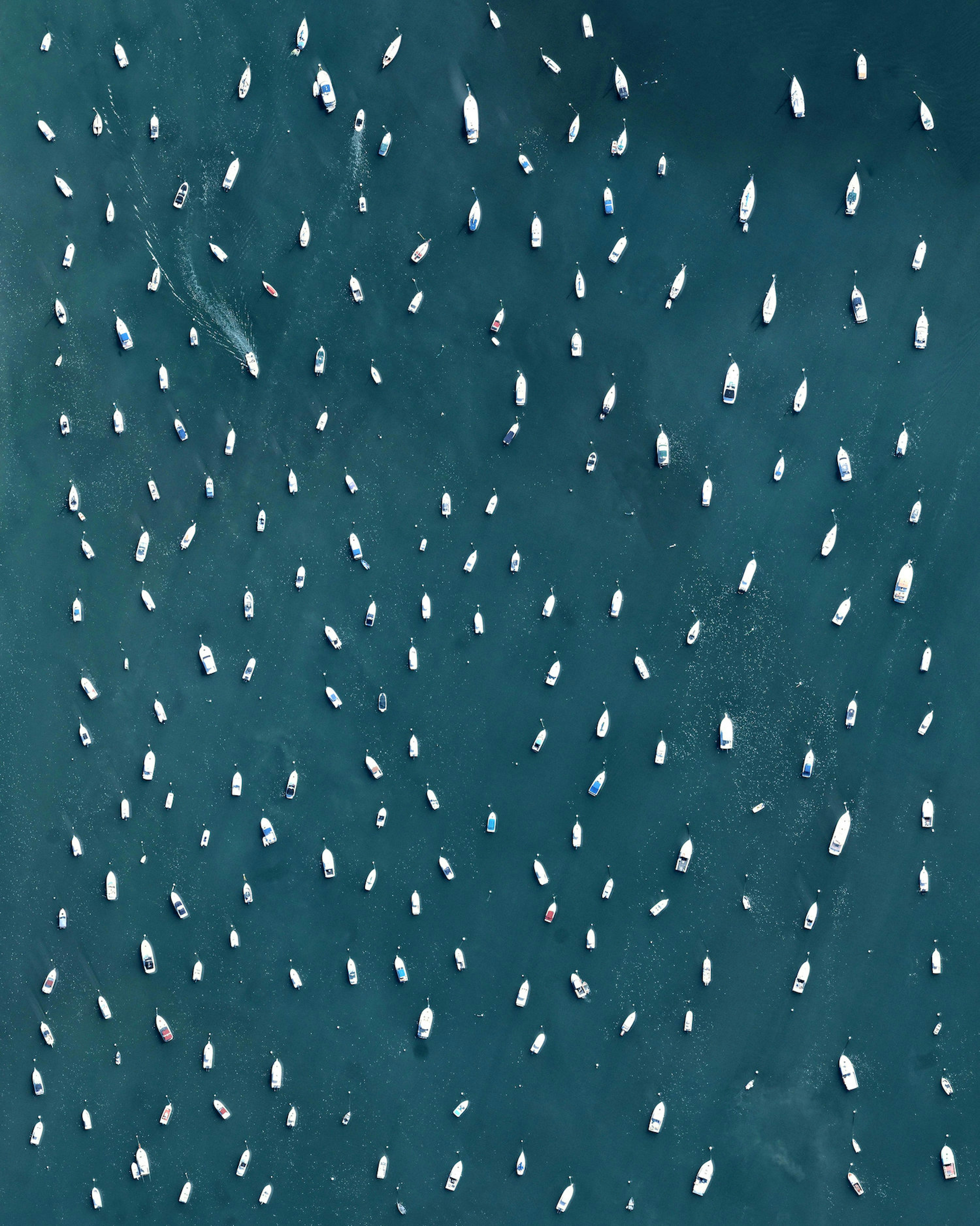
Plymouth Rock Boats
Boats are moored in the waters by Plymouth Rock in Massachusetts, USA. A nearby site onshore is recognized as the disembarkation point of William Bradford and the Mayflower Pilgrims who founded Plymouth Colony in 1620. The following year, in 1621, a feast was held to celebrate a bountiful harvest, which is commonly recognized as the first Thanksgiving.
41.958333°,-70.661944°
Nearmap

Beach Haven West
Beach Haven West is an unincorporated community and census-designated place in Stafford Township, New Jersey. The neighborhood, which has about 3,900 residents, was built upon salt marshes beginning in the 1950s. Looking at this Overview, it is evident that Beach Haven West was supposed to continue growing; however, a lack of permits from the Environmental Protection Agency and the Wetlands Protection Act of 1970 prevented it from expanding further across the Mill Creek delta.
39.670417°,-74.233111°
Nearmap

Kwinana Beach Tire Graveyard
A forklift divides thousands of tires into uniform sections on a large lot in Kwinana Beach, Western Australia. Kwinana Beach is an industrial suburb of Perth that contains several large petro-chemical refineries, including those run by BP and Alcoa. In the 1970s, many residents of the suburb accepted property resumption offers from the local government citing increased pollution, health problems, and other nuisances caused by growing industrial development.
-32.217833°,115.774083°
Nearmap

Third Avenue Bridge
Third Avenue Bridge passes over Upper Saint Anthony Falls on the Mississippi River in Minneapolis, Minnesota. Originally, the Falls of Saint Anthony was the only natural major waterfall on the Upper Mississippi River; however in the 1950s and 1960s, a series of locks and dams was constructed to extend navigation to points upstream. A small portion of the lock system can be seen in the bottom right of this Overview. Surrounding this area is a 1.8-mile (2.9-km) self-guided walking trail with signs explaining the area's history.
44.982972°,-93.259417°
Nearmap

LaSalle, Colorado Cattle Feedlot
In this Overview, thousands of cattle can be seen on a feedlot in LaSalle, Colorado -- a small town roughly 50 miles (80 km) north of Denver. This particular feedlot has a capacity for 69,000 cows and is one of several owned by the largest cattle feeding company in the world. Other feedlots owned by company, located in Arizona, Idaho, Kansas, Oklahoma and Texas, have an estimated total feeding capacity of more than 900,000 head of cattle.
40.325417°,-104.778639°
Nearmap

Rovinj
Rovinj, officially known as Rovinj-Rovigno, is a city in Croatia with roughly 15,000 residents. Located on the Istrian Peninsula in the north Adriatic Sea, it is a popular tourist destination and an active fishing port. Most people in Rovinj are bilingual, speaking Croatian and Italian — and a handful even speak Istriot, an endangered Romance language with less than 1,000 speakers left.
45.083333°,13.633333°
Maxar Technologies

Adelaide Canola Flowers
Yellow canola fields are visible across the landscape north of Adelaide, Australia. While various crops are grown here, the canola fields are easy to notice because of their vibrant flowering color. The crop is grown for the production of oil, which is extracted by slightly heating and then crushing the flower seeds. Canola oil is primarily used as a source of biodiesel and also for cooking purposes.
-34.439861°,138.557833°
Nearmap

Griend
Griend is a small, uninhabited Dutch island located in the Wadden Sea, roughly 62 miles (100 km) northwest of Amsterdam. In the Middle Ages, the island housed a walled settlement and monastery, which were destroyed by St. Lucia’s flood in 1287. Later, a few farmers inhabited Griend between the 18th and 19th centuries, but continuous erosion pushed them away — the island remains only 25 acres (10 hectares) in size today.
53.251389°,5.254167°
Maxar Technologies
