To receive our daily post and the occasional announcement:

Halong Bay
Hạ Long Bay, located in the Quảng Ninh Province of Vietnam, is a stunningly beautiful destination. Here, towering limestone pillars and tiny islands topped by a rich, green forest rise from the beautiful waters of the Gulf of Tonkin. Halong translates as 'where the dragon descends into the sea' and local legend suggests that this seascape was created when a great mountain dragon charged towards the coast, its flailing tail gouging out the valleys and crevasses in its path.
20.900000°,107.200000°
Maxar Technologies

Glastonbury Festival
The Glastonbury Festival concluded yesterday in Pilton, England. The annual, five-day music event was attended by more than 135,000 people. Concert-goers are provided a campsite at the venue but must bring their own tents - which vividly dot the landscape in this Overview. The population of Pilton on the other 360 days of the year is 998.
51.148500°,-2.714000°
Maxar Technologies

Fucino Plain
The plain of Fucino in the Abruzzo region of Italy is commonly recognized for the quality of the vegetables that are grown here - in particular the potatoes, carrots, and radishes. What is now an entire plain filled with farms was once Fucine Lake, the third largest lake in Italy. The lake was drained in 1877 to make agricultural development possible here, an area that is now responsible for roughly 25% of the agricultural production in the region.
42.004370°,13.529060°
Maxar Technologies

Everglades National Park
Everglades National Park in Florida is the largest tropical wilderness in the United States east of the Mississippi River, covering more than 1.5 million acres. The park was established in 1934 to protect the area’s fragile ecosystem and is home to 36 threatened or protected species including the American crocodile and West Indian manatee.
25.364334°,-81.121068°
Maxar Technologies

The Empty Quarter
Rub’ al Khali — or “The Empty Quarter” — is the largest sand desert in the world. It covers 251,000 square miles (650,000 sq. km) and includes parts of Saudi Arabia, Oman, Yemen, and the United Arab Emirates. In the center of the desert there are a number of raised, hardened formations that were once the sites of shallow lakes, thousands of years ago.
19.748556°,53.126000°
Maxar Technologies

Eixample District - Barcelona
The Eixample district in Barcelona, Spain, is characterized by its strict grid pattern and apartments with communal courtyards. This thoughtful and visionary design was the work of Ildefons Cerdà. His plan features broad streets that widen at octagonal intersections to create greater visibility with increased sunlight, better ventilation, and more space for short-term parking.
41.392184°,2.164928°
Maxar Technologies

Tulip Fields
Lines of colorful tulips in Lisse, Netherlands to honor the birthday of my favorite artist, Piet Mondrian! The Netherlands, where Mondrian was born on this day in 1872, produces 4.3 billion tulip bulbs every year. Mondrian is most well known for his paintings with straight black lines and blocks of the three primary colors.
52.276356°,4.557081°
Maxar Technologies

Del Ray Beach
A residential community is seen here in Delray Beach, Florida, USA. Because many cities in the state of Florida contain master-planned communities, often built on top of waterways in the latter half of the twentieth century, there are a number of intricate designs such as this one that are visible from the Overview perspective.
26.475548°,-80.156470°
Maxar Technologies

Del Ray Beach
This Overview captures residential communities in Delray Beach, Florida, USA. According to the 2010 census, 20.4% of the town’s 34,156 households are vacant.
26.476432°,-80.155327°
Maxar Technologies

Dallas/Fort Worth International Airport (DFW)
Dallas/Fort Worth International Airport covers more than 27 square miles (70 sq. km) in Texas — an area larger than the island of Manhattan. It is the fourth busiest airport in the world by aircraft movements and the 14th busiest in the world in terms of passenger traffic, handling 69.1 million travelers in 2018.
32.896944°,-97.038056°
Maxar Technologies
Crescent Dunes Solar Energy Project
The Crescent Dunes Solar Energy Project near Tonopah, Nevada powers up to 75,000 homes during peak electricity periods. So how does it work? The project uses 17,500 heliostat mirrors to collect and focus the sun’s thermal energy to heat molten salt flowing through a 540-foot (160 m) tall solar power tower. The molten salt then circulates from the tower to a storage tank where it is used to produce steam and generate electricity. One last thing - look closely at the lower left corner of this Overview and you’ll see an airplane flying over the complex!
38.238972°,-117.363721°
Maxar Technologies

Rice paddies
Rice paddies, constructed in steps, cover the mountainsides of Yuanyang County, China. Cultivated by the Hani people for the last 1300 years, the slope of the terraces varies from 15 to 75 degrees with some having as many as 3,000 steps.
23.158998°,102.755424°
Maxar Technologies
Chilean Coast Range
Check out this amazing Overview of the Chilean Coast Range, which runs along the Pacific coast of Chile. It extends 1,900 miles (3,100 km) from north to south, and this image captures a section near the city of Antofagasta. The highest point in the Chilean Coast Range is Cerro Vicuña Mackenna, which peaks at 10,217 feet (3,114 m).
-24.737494°,-70.565057°
Maxar Technologies

Central Park
This Overview captures Central Park in New York City. Located in the middle of Manhattan, the park spans 843 acres — or 6% of the borough. One of the most influential innovations in the park's design was its "separate circulation" systems for pedestrians, horseback riders, and automobiles. This concealed "crosstown" commercial traffic in sunken roadways (known as "transverses" today), and densely planted shrub belts in order to maintain a rustic ambiance.
40.782222°,-73.965278°
Maxar Technologies
Cape Cod
Cape Cod is a hook-shaped peninsula that extends into the Atlantic Ocean off southeastern Massachusetts, USA. The 15 towns on the cape are a popular summer destination with quaint villages, seafood shacks, lighthouses, and many beaches. The three towns at the northernmost tip of the cape — Wellfleet, Truro, and Provincetown — are visible in this Overview.
41.797291°,-70.868541°
Maxar Technologies

Luoping County Canola Flowers
Canola flower fields cover the mountainous landscape of Luoping County, China. The crop is grown for the production of oil, which is extracted by slightly heating and then crushing the flower seeds. Canola oil is primarily used as a source of biodiesel and is also a key ingredient in many foods.
24.885000°,104.308056°
Maxar Technologies

Calipatria Fields
Agricultural development is seen in Calipatria, California, USA. At an elevation of 180 feet (55 m) below sea level, the city has the lowest elevation in the western hemisphere.
33.116410°,-115.627270°
Maxar Technologies
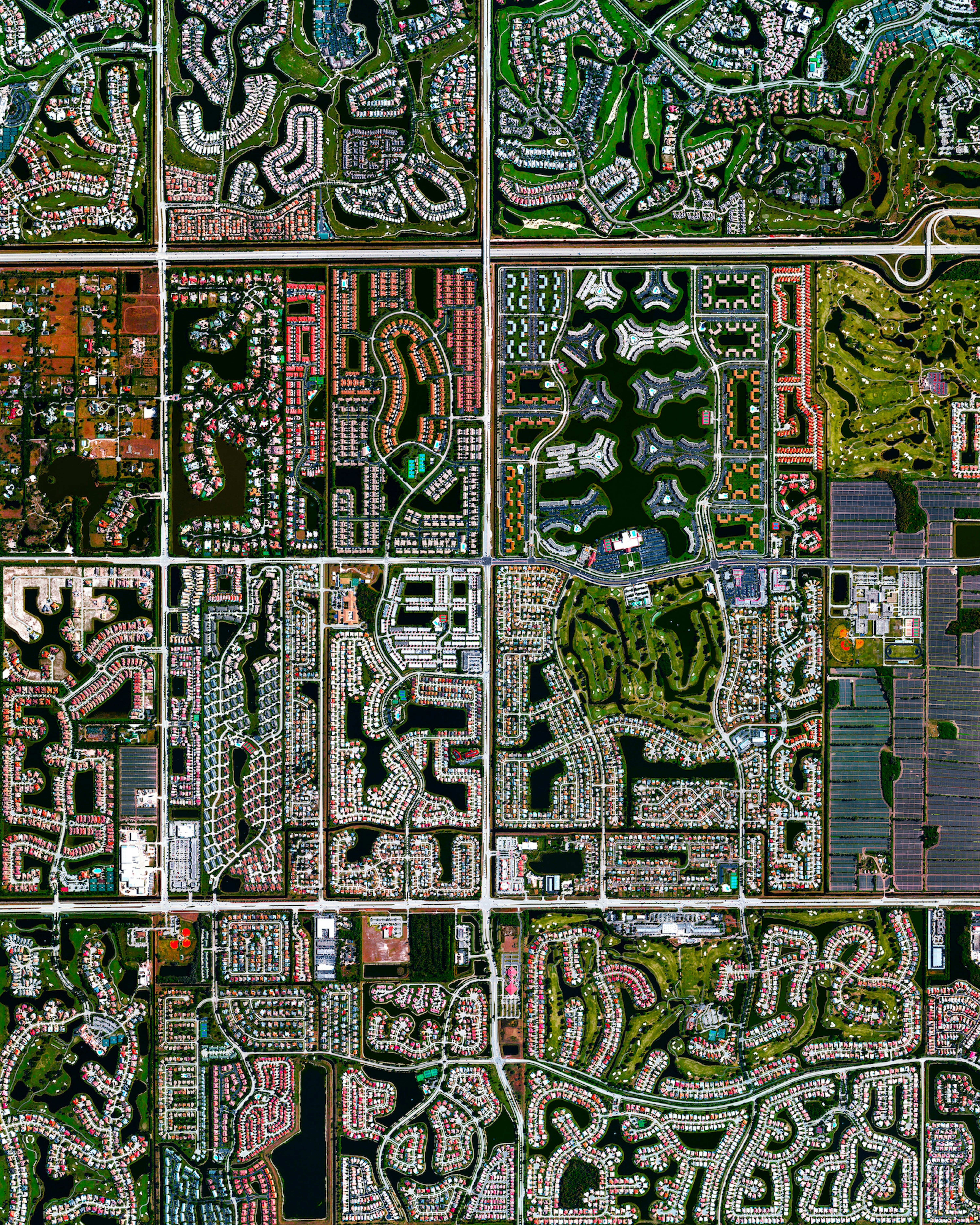
Boca Raton, Florida
Residential development is seen in Boca Raton, Florida, USA. Because many cities in the state contain master-planned communities, often built on top of waterways in the latter half of the twentieth century, there are a number of intricate designs that are visible from the Overview perspective. Boca Raton is home to roughly 91,000 residents.
26.386333°,-80.179917°
Maxar Technologies
Boca Raton
Residential development is seen in Boca Raton, Florida, USA. Because many cities in the state contain master-planned communities, often built on top of waterways in the latter half of the twentieth century, there are a number of intricate designs that are visible from the Overview perspective. Boca Raton is home to roughly 91,000 residents.
26.386332°,-80.179917°
Maxar Technologies

Bahamas Clouds
Clouds cover the Atlantic Ocean in the waters off of The Bahamas.
23.919435°,-79.882190°
Maxar Technologies
