To receive our daily post and the occasional announcement:

Port of Antwerp
The Port of Antwerp in Flanders, Belgium, is the second-largest seaport in Europe. Its inland location on a tidal estuary of the Scheldt River gives it an advantage over other North Sea ports, allowing its docks to connect to rail, road, river and canal transit systems. In 2018, nearly 14,600 seagoing vessels called at the Port of Antwerp with a combined transshipment of 235.2 million tonnes.
51.270000°,4.336667°
Maxar Technologies

Bayannur Wulanyiligeng Wind Farm
The Bayannur Wulanyiligeng Wind Farm in Inner Mongolia, China, consists of at least 200 wind turbines and can generate nearly 850,000 megawatt hours (850 billion watt hours) of power per year at full operation. Power from the wind farm is sold to the North China Power Grid to substitute for power generated by thermal power plants, thus reducing carbon emissions. The wind farm has the capacity to reduce carbon dioxide emissions by more than 760,000 tonnes annually.
41.963889°,108.308333°
Maxar Technologies

Toronto
Toronto is the most populous city in Canada, with upwards of 5.9 million people living in its metropolitan area. It is considered one of the most multicultural and cosmopolitan cities in the world; in fact, more than 50 percent of Toronto's residents belong to a visible minority group and more than 160 languages are spoken in the city. This Overview shows several of Toronto's neighborhoods, including pieces of East York, North York and Scarborough.
43.718155°,-79.518484°
Maxar Technologies

Seymour Johnson Air Force Base
Planes sit under coverings on the tarmac of Seymour Johnson Air Force Base in Goldsboro, North Carolina. The base was established in June 1942 and served as a training facility throughout World War II before it was deactivated in May 1946. Since reopening as a Tactical Air Command Base in 1956, it has been home to B-52 bombers, KC-10 and KC-135 tankers, and F-4 and F-16 fighters.
35.351000°,-77.963000°
Nearmap

Kuta
Kuta (also known as Kuta Village or Kuta Town) is a village in southern Bali, Indonesia. Originally a small fishing community, it was one of the first places in Bali to see substantial tourism and has become internationally known as a beach resort town. Kuta sits just north of Ngurah Rai International Airport, which is shown at the center of this Overview jutting out into the Indian Ocean.
-8.733333°,115.166667°
Maxar Technologies

Cyclone Idai
Over the past week, Cyclone Idai has wreaked havoc on countries in eastern Africa, causing strong winds and severe flooding in Madagascar, Mozambique, Malawi and Zimbabwe. This image, captured by the European Space Agency's Copernicus Sentinel-3 satellite, shows the cyclone on March 13 off the west coast of Madagascar. Hundreds of people have been killed in the disaster, and thousands more are stranded or missing.
-18.771924°,42.371307°
ESA

Lake Mead
Lake Mead — located on the Colorado River 24 miles (38 km) southeast of Las Vegas, Nevada — is the largest reservoir in the United States. The lake was formed with the creation of the Hoover Dam in the 1930s. Due to a combination of drought and increased water demand in the surrounding states (specifically California, Nevada, New Mexico, and Arizona) the lake’s water level has been lowering drastically in recent years. This decreasing water level exposes the white shoreline that is visible in this Overview.
36.221287°,-114.747849°
Maxar Technologies

Cars At Philadelphia Navy Yard
Thousands of automobiles fill a large lot near the Philadelphia Navy Yard in southern Philadelphia, Pennsylvania. Since 2010, when Hyundai and Kia Motors moved their import businesses to the city, several large lots like this have popped up to accommodate an influx of new vehicles. At least 120,000 vehicles a year have arrived at the Port of Philadelphia since 2011, and more than 155,000 were delivered in 2015.
39.894037°,-75.179375°
Nearmap

Nebraska Iowa Flooding (Juxtapose)
These jaw-dropping juxtaposes shows farmland at the Nebraska-Iowa border before and after catastrophic flooding occurred there last week. Floods across the Missouri River Basin were caused by heavy rainfall and rapid snowmelt, and the total cost of damages in Nebraska has exceeded $1.3 billion. At least 2,000 homes and 340 businesses have been damaged or destroyed, and losses to infrastructure, farmland and livestock are monumental.
41.021611°,-95.849611°
Maxar Technologies

Cypress Village
Uniform apartment buildings are seen here at Cypress Village, a township in Irvine, California. As a master-planned city, Irvine contains dozens of communities like this — each one having houses of a similar design, along with commercial centers, religious institutions, and schools. Irvine is one of the wealthiest cities in the western United States, with a median household income of $90,743 and a median home value of $784,500.
33.691889°,-117.759139°
Nearmap

Chicago Tractor-Trailer Hub
Trailers are docked and loaded at the Chicago Area Consolidation Hub, a package sorting facility in Hodgkins, Illinois. This 1.5 million square foot (139,355 sq. m) facility is owned by the United Parcel Service (UPS) and handles packages traveling throughout the United States and world. Roughly 1.5 million packages pass through its more than 65 miles (105 km) of conveyor belts every day.
41.750750°,-87.878611°
Nearmap

San Francisco Bay Container Ship
A ship full of containerized cargo navigates San Francisco Bay, located between San Francisco and Oakland, California. Due to San Francisco's limited real estate, Oakland has served as the primary Bay Area port since the 1960s. The Port of San Francisco handled no containerized cargo in 2017, whereas the Port of Oakland had a throughput of nearly 2.5 million twenty-foot equivalent units (TEUs) that year.
37.767035°,-122.417378°
Nearmap

Cape Town
Cape Town is a port city on South Africa’s southwest coast. The city’s geography is influenced by the surrounding Table Mountain, the Durbanville Hills, and the expansive lowland region known as the Cape Flats. These geographic features divide the city into several commonly known suburbs, many of which developed simultaneously and share common attributes of language and culture. This unique blend has made Cape Town one of the most multicultural cities in the world, attracting tourists, immigrants, and expats to South Africa.
-33.925278°,18.423889°
Maxar Technologies

Dorsoduro Sestiere - Venice
This Overview shows part of the Dorsoduro sestiere in Venice, Italy. A sestiere — which comes from the Italian “sesto,” meaning sixth — is a subdivision of an Italian town or city divided into six districts. Dorsoduro is Venice’s university district and is filled with bars, restaurants, indie shops, vintage fashion boutiques and art galleries, such as the Peggy Guggenheim Collection.
45.430361°,12.333444°
Maxar Technologies
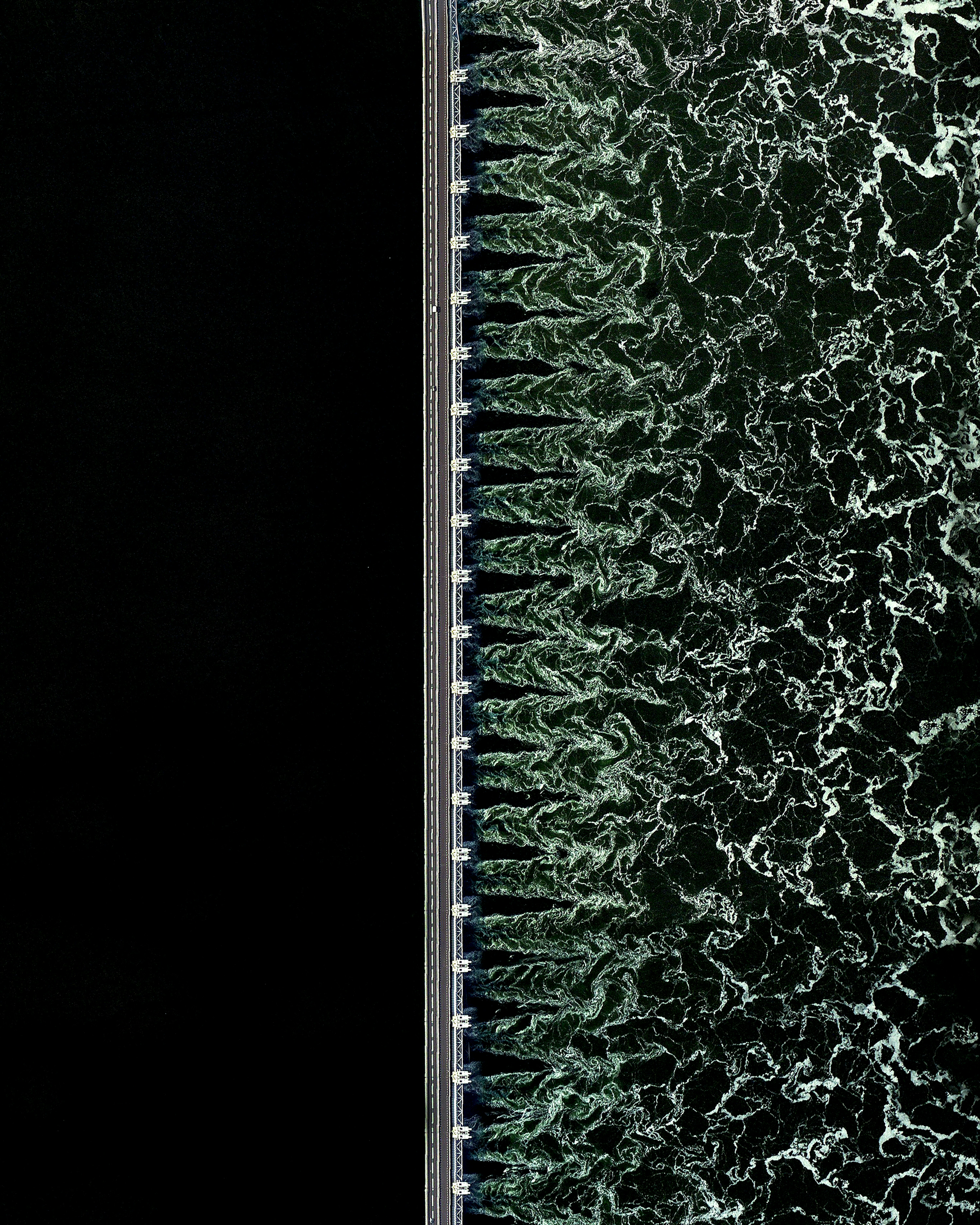
Oosterscheldekering
The Oosterscheldekering (Eastern Scheldt storm surge barrier) is the largest in a series of 13 dams designed to protect the Netherlands from North Sea flooding. It spans about 5.6 miles (9 km) between the islands of Schouwen-Duiveland and Noord-Beveland, containing large sluicegate-type doors that can be closed under adverse weather conditions. Designed to last more than 200 years, the Oosterscheldekering is sometimes referred to as the eighth Wonder of the World.
51.608691°,3.681047°
Maxar Technologies

Aral Sea
The Aral Sea was an endoheic lake (one with no outflow) located between Kazakhstan and Uzbekistan. Once the fourth largest lake in the world with an area of 26,300 square miles (68,000 sq. km), it has been shrinking since the 1960s after rivers that fed it were diverted by Soviet irrigation projects. By 1997, it had declined to 10% of its original size and split into four lakes, one of which has since disappeared. The shrinking of the Aral Sea has been called one of the planet's worst environmental disasters.
45.510578°,58.757118°
Maxar Technologies

The Pearl - Qatar
The Pearl-Qatar is an artificial island in Doha, Qatar, spanning nearly 2.5 miles (4 km) in the Persian Gulf. Once completed, the island is expected to have nearly 19,000 dwellings and 45,000 residents. Twelve precincts make up the Pearl-Qatar, and each one has a national or international theme — including aspects of Arabic, Mediterranean and European culture.
25.368611°,51.551944°
Maxar Technologies

Hạ Long Bay
Hạ Long Bay, located in the Quảng Ninh Province of Vietnam, is a stunningly beautiful destination. Here, towering limestone pillars and tiny islands topped by rich, green forests rise from the waters of the Gulf of Tonkin. Halong translates as 'where the dragon descends into the sea' and local legend suggests that this seascape was created when a great mountain dragon charged towards the coast, its flailing tail gouging out the valleys and crevasses in its path.
20.843408°,107.009542°
Maxar Technologies

Petare, Venezuela
Petare is a city in northern Venezuela, and is part of the greater Caracas urban area. With a population of nearly 370,000, it is considered one of the largest slums in the world. Homes in Petare are packed tightly together and many are stacked on top of each other along landslide-prone hills.
10.483861°,-66.803028°
Maxar Technologies

Alakol Lake
Alakol Lake is a 1,020-square-mile (2,650 sq. km) salt lake located in east central Kazakhstan. The lake, which aptly translates to "multicolored lake," has varying shades of blue and green depending on its depth, levels of phytoplankton, and sediments flowing in from rivers and streams. Its mineral-rich water and mud are believed to be therapeutic, attracting many visitors who seek a natural remedy for psoriasis and other skin ailments.
46.104867°,81.178937°
Maxar Technologies
